On a dusty roadside in Kenya’s Great Rift Valley, a bus slows and schoolchildren lean forward, pressing their faces to the glass. Outside, the land has torn open. A fresh crack cuts through farmland where goats once grazed. A teacher points and jokes that Africa is breaking apart right here. The children laugh, but a few stay quiet, watching the earth as if it has spoken. The smell of wet soil mixes with diesel fumes. Nearby, a shepherd calmly leads his animals around the rupture, unfazed. What looks like a sudden accident is actually part of a story far older and far bigger than anyone on that bus.
Africa Is Slowly Pulling Itself Apart
The East African Rift is one of the most dramatic places on Earth, not because it moves fast, but because it moves at all. Standing at its edge, the ground feels solid beneath your feet. Yet the landscape tells a different story. Steep escarpments drop into wide valleys. Volcanoes rise in the distance. Long lakes fill deep fractures in the crust. This is not erosion alone. It is the visible surface of a continent being stretched.

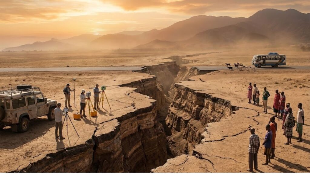
Africa is not cracking in a single violent moment. It is thinning, slowly and persistently. The eastern part of the continent is drifting away from the rest, millimeter by millimeter, year after year. In 2018, images of a massive crack near Mai Mahiu in Kenya went viral after heavy rains tore open a road. While rainfall and erosion played a role, geologists confirmed the location sat directly within the rift zone. What shocked the public was not the damage itself, but the realization that this slow geological process is already visible.

Satellite measurements now leave little room for doubt. GPS stations anchored deep into bedrock show parts of East Africa moving away from the main African plate by a few millimeters each year. On a human scale, that distance feels meaningless. Over a million years, it becomes hundreds of kilometers. The math is simple, and the conclusion is unavoidable. This movement will eventually create a new ocean basin.
The Hidden Forces Tearing the Continent from Below
Tracking a continent in motion requires patience and precision. Across East Africa, scientists install GPS antennas that measure their position to within millimeters every day. These instruments quietly record a story of separation.
One of the clearest examples lies in Ethiopia’s Afar region, a stark landscape of salt flats and volcanoes. Here, three tectonic plates are pulling apart from a single point, forming what geologists call a triple junction. In 2005, the ground split open along a 60-kilometer stretch in just a few days as magma surged upward. Villages woke to find cracks slicing through fields. For residents, it was alarming. For scientists, it was like watching the earliest stage of an ocean being born.
Beneath East Africa, heat from deep within the Earth rises toward the surface. This hot mantle material weakens the crust, causing it to bulge, fracture, and sink. As the land stretches, it thins, much like dough pulled too far across a table. Over immense spans of time, these fractures deepen. Magma fills the gaps. Eventually, seawater follows. Far in the future, the eastern portion of Africa will drift away as a separate landmass, divided by a new ocean where savannas and cities once stood.
Living on Ground That Will Not Stay Still
For the millions of people who live along the rift, this is not an abstract scientific theory. Farmers in Kenya and Tanzania already notice subtle changes. New cracks appear after earthquakes or heavy rains. Some land slowly sinks. Volcanoes remain active.

Scientists use satellite radar, GPS data, and ground surveys to map the rift in fine detail. This information helps governments decide where roads, pipelines, and power lines should be built or avoided. No one living in the rift will wake up tomorrow to an ocean view. The process is far too slow for that. The real challenge is managing an unstable landscape over generations.
Dramatic headlines often suggest that Africa splitting means an imminent catastrophe. That misunderstanding fuels fear. Geological change operates on timescales that are hard to grasp. The risks are real, but they are gradual and manageable with planning. Researchers working in these regions emphasize that their work is not only about rocks and maps. It is about homes, livelihoods, and cultural ties to land that is slowly changing shape.
Practical planning already focuses on clear priorities:
Infrastructure should avoid the most active fault zones where possible.
Monitoring networks for earthquakes and volcanoes need long-term funding.
Risk information must be shared clearly in local languages.
Roads and pipelines should be designed to adapt as the ground shifts.
Communities affected by land instability need support, not abandonment.
A Continent That Changes How We Understand Time
The idea of Africa splitting in two sounds like science fiction, yet the evidence lies in plain sight. Rift valleys, volcanoes, and deep lakes are all chapters of the same slow story. These images often flash across screens and disappear just as quickly. But this is not a story meant to be skimmed.
It forces us to think beyond human lifespans and political borders. It reminds us that continents are not fixed shapes on a map. They are temporary arrangements in constant motion. Africa did not always look the way it does today, and it will not look this way forever.
Millions of years from now, a new coastline will exist where wildlife now grazes in the Rift Valley. The process is already underway, measurable and unstoppable. The ground beneath East Africa is quietly rewriting the map, one millimeter at a time.