Scientists are warning that as the planet heats up, episodes of extreme rainfall will not only intensify, but cluster over the same areas again and again. While Europe may experience relatively modest shifts, other parts of the globe are on track for a dangerous surge in destructive downpours.
Where extreme rain becomes a way of life
Global warming loads the atmosphere with more moisture. That extra water has to go somewhere, and it usually falls in short, violent bursts. Climate researchers, using several independent models, have mapped how often such events could hit different regions of the world by 2100.

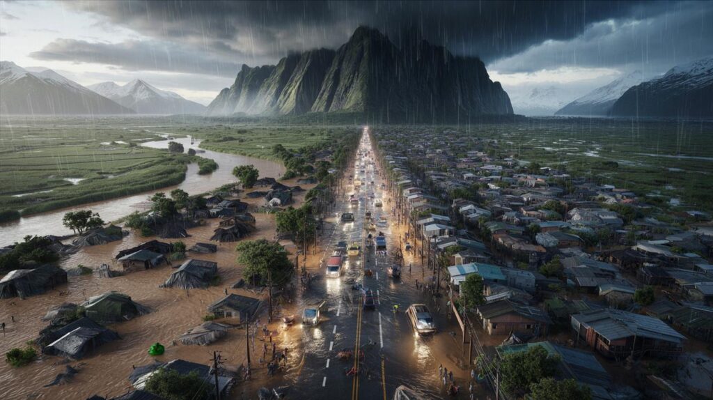
Some countries are projected to face such frequent, intense rains that large parts could feel practically uninhabitable for long stretches of the year.

The analysis groups regions by the expected increase in episodes of extreme precipitation, from modest changes to sharp jumps in risk. The broad picture is stark: while a few areas will see only a mild rise, others are headed for a future where “once‑in‑a‑century” storms roll through every few years.
The zones most at risk
Using five separate climate models, researchers coloured the globe: blue for regions with the smallest increase in heavy rainfall, orange and red for those with the steepest rise. The red zones, in particular, point to countries that must brace for more floods, landslides, and infrastructure failures.
- Tropical and subtropical regions already prone to monsoon rains
- Rapidly urbanising coastal zones in Asia and Africa
- Cold regions like Alaska, where warming is accelerating changes in precipitation
- Mountainous areas exposed to both intense rain and sudden snowmelt
In several of these places, homes, roads, and power networks were never designed for the future level of rainfall. The risk is not just wetter days, but more unliveable ones, when entire districts are cut off.
Europe’s uneasy “lucky break”
Compared with other continents, Europe looks relatively spared. The latest modelling suggests that much of the continent will not face a dramatic surge in extreme rain events, at least not on the scale projected for parts of Asia, Africa or the Americas.
France falls into the category with one of the weakest projected increases in heavy rainfall, though that does not mean zero risk.
Researchers note that the Mediterranean fringe of France – especially the south-east – could still see a more marked rise in intense downpours. This area already experiences “cévenol” events, those brutal autumn storms that dump a month’s worth of rain in a few hours. A modest increase in their frequency or intensity could carry costly consequences.
Why Europe still cannot relax
Even with limited changes in overall statistics, Europe’s built environment remains vulnerable. Many older cities were constructed beside rivers or coastlines with historical flood patterns in mind, not the altered conditions of a warmer climate.
Urban sprawl has also paved over natural drainage zones. When a heavy storm hits, water runs off tarmac and concrete straight into drains and rivers, overwhelming systems that worked fine decades ago. Small shifts in daily rainfall can then translate into big jumps in flood damage.
Alaska and the cold regions on the frontline
Among the more surprising areas flagged by researchers is Alaska. Traditionally known for snow and permafrost, it is now warming at roughly twice the global average. That warming changes how, when and where water falls.
Warmer air over Alaska can hold more moisture, turning what used to be light snow events into heavy rainstorms, sometimes falling on still-frozen ground.
Rain on snow is particularly hazardous. It can trigger sudden melt, flush out unstable slopes and generate flash floods in valleys that rarely saw them in the past. For remote communities, a single severe event can cut access to hospitals, food supplies or fuel for weeks.
Other cold and mountainous regions face similar threats. As glaciers shrink and permafrost thaws, slopes lose their natural “glue”. Add heavier rain, and the risk of catastrophic landslides rises sharply.
From rare disaster to recurring stress
One of the biggest shifts involves frequency. Storms that once seemed like freak occurrences could become part of the normal climate. Infrastructure designed for one catastrophic failure in a lifetime may instead be tested every decade, or even every few years.

For many countries, that means a gradual erosion of liveability rather than a single tipping point. Fields stay waterlogged for longer. Roads need constant repairs. Insurance premiums climb. Young people move away from the most exposed districts, leaving behind older populations with fewer resources to adapt.
The human cost behind the maps
When scientists talk about “inhabitable” or “uninhabitable” by 2100, they rarely mean that entire countries will be abandoned. The concern is that certain low‑lying neighbourhoods, river valleys or coastal strips might be flooded or disrupted so often that normal life there becomes unrealistic.
Repeated extreme rains can slowly turn high‑risk zones into places where only those with no other option continue to live.
This is already visible in parts of South Asia and Central America, where recurring floods push families to migrate seasonally or permanently. Similar patterns may spread to new regions as climate change accelerates.
Who must adapt the fastest
Countries facing a steep increase in extreme rainfall share a few traits that make adaptation urgent:
| Type of region | Main vulnerability | Key adaptation need |
|---|---|---|
| Low-lying coastal cities | Storm surges and drainage failures | Improved sea defences and pumping systems |
| Mountain valleys | Landslides and flash floods | Early warning systems and slope stabilisation |
| Informal urban settlements | Poor housing and lack of services | Safe housing programmes and basic infrastructure |
| Rural floodplains | Crop loss and isolation | Climate-resilient agriculture and raised roads |
In many of these places, the choice is between making big investments now or paying far more later through disaster relief, reconstruction, and social upheaval.
Why warmer air means heavier rain
The basic physics behind these projections is relatively straightforward. For roughly every degree Celsius of warming, the atmosphere can hold about 7% more water vapour. When conditions trigger rain, that extra moisture can fall rapidly, creating stronger downpours.
Climate models combine this physical rule with data on winds, geography and ocean temperatures to simulate storms. While there is still uncertainty in the precise numbers, different models consistently point to a rise in short, intense rain events rather than gentle all‑day drizzle.
What “extreme rainfall” actually means
The term “extreme rainfall” usually refers to events that fall in the top 1% or 0.1% of observed daily totals in a given region. That might be 50 mm in a day in a temperate climate, or more than 200 mm in a monsoon zone.
Scientists track how often these rare extremes occur in the historical record and then see how their frequency changes in simulations of a warmer climate. A doubling or tripling of those events, even if the baseline number is small, represents a major shift in risk.
The combined punch of rain, sea and rivers
One aspect that worries hydrologists is the combination of multiple hazards. Extreme rainfall often coincides with already high river levels or storm-driven coastal surges. When these overlap, the damage multiplies.
The danger is not just heavier rain, but heavier rain falling on saturated ground, swollen rivers and rising seas.
A city that might cope with any one of these factors can buckle when all three hit together. That is when flood defences are overtopped, sewers back up, and emergency services struggle to reach those in need.
Looking towards 2100, countries highlighted in orange and red on those climate maps are not doomed, but they do face hard choices. Rethinking where to build, how to drain water and which areas to protect at all costs will shape whether their most at‑risk regions remain liveable or slowly slide towards being “inhabitable” only on paper.