The sky over Chicago had that strange, metallic color you only see before something big. People waiting for the L huddled deeper into their coats, phones in hand, watching radar loops stutter over the Great Lakes. On weather maps, a tight swirl of purple and blue was diving down from the Arctic like a thrown spear, moving faster than forecasters were comfortable admitting on live TV.
Inside the National Weather Service office, one meteorologist muttered, “This is… not behaving normally,” then caught himself as the camera light turned red. Screens around him glowed with decades of winter data, and the numbers simply didn’t line up.
Somewhere between the models and the real world, a rulebook was quietly being shredded.
The polar vortex that refuses to play by the rules
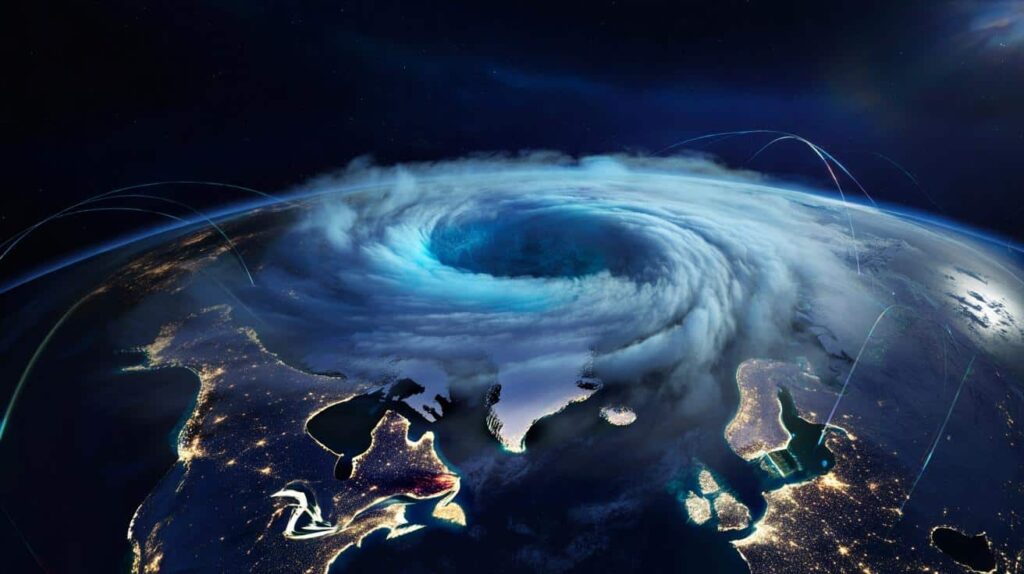
On paper, a polar vortex is supposed to be predictable. A ring of icy winds spinning neatly over the Arctic, wobbling south every few winters, then snapping back again. This time, that ring is buckling in odd places, sending a lopsided tongue of frigid air racing toward North America and parts of Europe.
Forecasters are watching the speed of this drop with a mix of fascination and unease. The cold pool is sliding south days earlier than their seasonal models projected, and the usual “buffer zones” of milder air are thinner. For people on the ground, that means less warning between “mild December” and “record-breaking freeze.”
One senior forecaster in Minneapolis describes staring at side‑by‑side maps from 1994, 2014 and 2024. The classic polar vortex years we all remember—frozen eyelashes, snapping power lines, the breath‑stealing walk from car to front door. Those maps show big, broad arcs of cold easing south. This year’s configuration looks different: more like a hooked claw, with sharper gradients and tighter pressure lines.
Temperatures are projected to swing 25–30°F in less than 36 hours across parts of the Midwest. In meteorology, that’s a red flag. Rapid drops of that scale strain energy grids, saturate emergency rooms, and leave municipalities scrambling to open warming centers on the fly. One city planner told me, half‑joking, “Our winter playbook feels like it’s written for another planet.”
Behind the screens and colored maps, the science points to a clash between long‑term climate warming and short‑term atmospheric chaos. A warming Arctic reduces the temperature contrast between the pole and mid‑latitudes, which can destabilize the jet stream that cages the polar vortex. When that cage weakens or warps, cold air spills south in odd directions, at odd times, and now at odd speeds.
This anomaly isn’t just colder or snowier than usual. It’s out of sync with the patterns weather offices built their baselines on in the 1980s and 1990s. That’s why you hear seasoned meteorologists, the type who’ve seen everything, now using words like “unusual configuration” and “climate‑era outlier” almost under their breath.
What you can realistically do when the air turns dangerous
The gap between the forecast and your front door is where things get real. Once this distorted polar vortex slides over your region, the margin for error shrinks fast. Think in terms of layers and timing, not heroics. Plan errands and commuting around the steepest temperature drop; those transition hours are when roads glaze over and black ice appears where there was just wet pavement.
At home, the boring tasks suddenly matter. Bleed outdoor faucets, draft‑proof a couple of key windows, clear the vent for your dryer and any gas heaters. None of this is glamorous. Yet those tiny moves can be the difference between an uncomfortable cold snap and a burst pipe or a carbon‑monoxide scare at 2 a.m.
We’ve all been there, that moment when the forecast sounds a bit dramatic and you shrug it off because last time it wasn’t that bad. This is exactly how people get caught without gloves, with low gas tanks, or with no backup heat source when the grid falters. Let’s be honest: nobody really does this every single day.
What helps is reframing it. You’re not prepping for some apocalypse; you’re just buying yourself options. Fill your prescriptions a few days early. Charge power banks. Move that extra blanket from the closet to the couch. These are small acts of control in a season that increasingly feels out of our hands.
As this anomaly bears down, some forecasters are dropping their usual poker face.
“From a climate perspective, this event is a warning shot,” says Dr. Lauren Hayes, a climatologist who has tracked polar vortex behavior for 20 years. “We’re seeing the kind of jet stream distortions we expected later in the century, not now. People need to understand this isn’t just ‘another cold winter.’ The backdrop has changed.”
You can translate that into a simple, boxed checklist you glance at when the first alert hits your phone:
- Charge devices and power banks before the front arrives.
- Identify one warm room to consolidate family and pets if heating fails.
- Keep a small kit in the car: blanket, hat, gloves, snacks, scraper.
- Know where your main water shutoff valve is, in case a pipe bursts.
- Save local non‑emergency and utility outage numbers in your phone.
What this vortex says about the winters we’re heading into
Beyond the headlines and viral TikToks of frozen hair and boiling water thrown into the air, something quieter is shifting. Climatologists who spend their lives buried in data are starting to speak more plainly. The speed and odd shape of this polar vortex event fit a larger story: winters are becoming more unstable, with sharper swings between mild and brutal, rain and ice, slush and deep freeze.
That doesn’t mean every year will be colder. It means the boundaries are blurring. The line between “safe to drive” and “stay home” gets crossed faster, sometimes in the space of a single commute. *The old mental calendar we used—snow by Christmas, deep freeze in January, thaw in March—no longer lines up with reality.* When reality stops matching our expectations, that’s when risk quietly multiplies.
| Key point | Detail | Value for the reader |
|---|---|---|
| Polar vortex anomaly | Unusual speed and lopsided configuration challenging decades of winter data | Helps you understand why forecasts feel more uncertain and urgent |
| Rapid temperature swings | 25–30°F drops within 36 hours in some regions | Signals when to adapt plans, protect pipes, and anticipate grid stress |
| Practical preparedness | Simple, low‑effort steps at home, on the road, and with devices | Gives you realistic actions instead of abstract climate anxiety |
FAQ:
- Question 1Is this polar vortex anomaly caused directly by climate change?
Not in a simple, one‑to‑one way. Climate change warms the Arctic and disrupts the jet stream, which can destabilize the polar vortex. That raises the odds of odd‑shaped, faster‑moving cold outbreaks like this one, but each event still has its own mix of natural variability.- Question 2Why does it feel so extreme if average winters are warming?
Warming shifts the baseline, yet it also seems to favor more swings—mild spells, then sharp plunges. You end up with fewer long, stable cold periods and more whiplash events that our infrastructure and habits aren’t built around.- Question 3Which regions should be most concerned this season?
Current projections highlight the central and eastern United States, parts of southern Canada, and sections of northern and central Europe. That path can still wobble. Local forecasts from trusted agencies will always be the best final word.- Question 4What’s the biggest mistake people make during these events?
Underestimating the speed of change. Roads, power grids, and bodies all handle slow shifts better than sudden ones. People look outside, see “just rain” or “just chilly,” and delay decisions until ice and deep cold are already in place.- Question 5How can I talk about this without sounding alarmist?
Stick to your lived reality and local facts. Mention how forecasts are changing, share one or two simple things you’re doing differently, and cite official sources. Curiosity and honesty land better than drama, especially when the air outside already feels hostile enough.